Methodology
From outcrop to ore body: a modern targeting workflow
How we combine geochemistry, structural mapping and gradient-boosted ML to compress months of fieldwork into a defensible target ranking.
Read article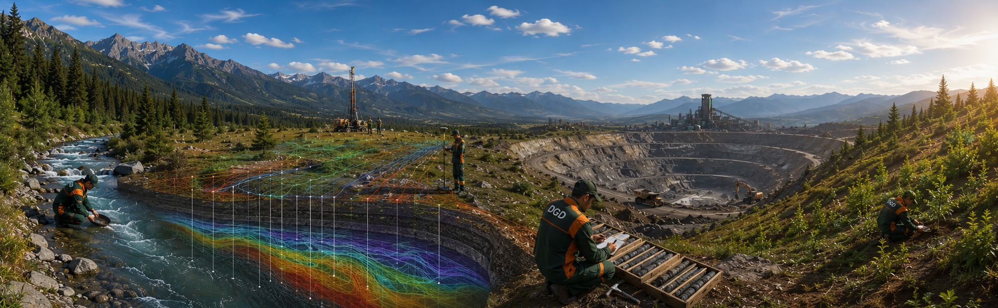
Field-tested geology, modern data science, and rigorous reporting — from outcrop to MRE, in one continuous workflow.
DGD Consulting is a modern company providing consulting and services in the field of geological exploration and mining.
The company's activities are aimed at conducting comprehensive geological, geochemical and geophysical surveys, surface exploration and drilling operations in order to identify promising areas and assess their potential.
In its activities, it combines knowledge and experience, modern technologies and international standards.
The company operates based on global industry requirements, with a deep understanding of local geological and territorial features, and aims to provide customers with long-term, reliable and innovative solutions.
Har bir qarorimiz, har bir hisobotimiz va har bir maydon ishimiz uchta asosiy tamoyilga tayanadi:
Geologik tadqiqotlarni atrof-muhitga minimal ta'sir bilan olib boramiz. Yer resurslaridan mas'uliyat bilan foydalanish — kompromissiz majburiyatimiz.
"Yer bizni boqadi — biz uni asraymiz."
Ko'p bosqichli tahlil va ehtiyotkorona rejalashtirish orqali texnik, moliyaviy va operatsion risklarni minimal darajaga tushiramiz.
"Puxta tayyorgarlik — eng yaxshi risk menejmenti."
Dala kuzatishlaridan yakuniy xulosalargacha — barcha natijalar aniq, tekshirilgan va xalqaro standartlarga muvofiq taqdim etiladi.
"Ishonchli ma'lumot — ishonchli hamkorlik."
Konsept tug'ilishidan kon qurilishi boshlangunga qadar — har bir bosqichda qaysi ishlar bajariladi va qanday natija beriladi.
Yangi loyiha yoki maydon bo'yicha mavjud barcha ma'lumotlar — geologik xaritalar, ilgari o'tkazilgan tadqiqotlar, davlat arxivlari, ilmiy nashrlar — to'planib chuqur tahlil qilinadi.
Desktop study xulosalari asosida eng istiqbolli maqsad zonalar — targetlar — belgilanadi. Bu bosqichda dastlabki dala tekshiruvlari, geokimyoviy namunalash va geofizik profiller o'tkaziladi.
Targetlangan hududlarda tizimli qidiruv ishlari olib boriladi. Detallanish o'sib boradi: kuzatuvdan burg'ilashgacha. Bu bosqich loyihaning texnik asosini quradi.
To'plangan ma'lumotlar JORC yoki NI 43-101 xalqaro standarti asosida mustaqil mutaxassis (Competent Person) tomonidan tahlil qilinadi. Kon hajmi, grade (foydali komponent miqdori) va ishonchlilik toifasi e'lon qilinadi.
MRE asosida loyihaning umumiy texnik-iqtisodiy maqsadga muvofiqligi tekshiriladi. Aniqlik darajasi past (±35–40%), lekin loyiha PFS'ga o'tishga arziydi-mi degan asosiy savolga javob beradi.
Loyihaning to'liq texnik-iqtisodiy asoslanishi. PFS dastlabki, FS yakuniy aniqlikda bajariladi. FS — bank, investor va hukumat uchun qabul qilinuvchi eng yuqori darajali texnik hujjat. Shu asosda qurilish va moliyalashtirish qarori qabul qilinadi.
Each service is delivered to international reporting standards, paired with full chain-of-custody data and a final document that holds up under audit.
Independent expert advice and technical supervision throughout all phases of geological study — from early-stage target selection through to resource estimation and feasibility.
Preparation of full project packages including technical programmes, work schedules, budget estimates, and regulatory submissions aligned with national and international requirements.
End-to-end management of trenching and drilling campaigns: hole design, contractor supervision, safety compliance, and real-time geological control on site.
Systematic core and chip logging, structured sampling programmes, and full QA/QC protocols — including standards, blanks, and duplicates — to ensure laboratory data integrity.
Systematic multi-element geochemical sampling and interpretation of primary (hypogene) and secondary (supergene) dispersion halos to vector towards ore zones.
Airborne (UAV-mounted) magnetics and radiometrics, ground-based IP, gravity and EM surveys, and downhole geophysics for structural and lithological interpretation.
Detailed structural mapping, kinematic analysis, and remote sensing — including multispectral and hyperspectral satellite imagery processing — to define ore-controlling structures.
Preparation of thin and polished sections from drill core or surface samples, followed by mineralogical and petrographic analysis under reflected and transmitted light.
Construction of lithological, structural, and mineralisation solid models using industry-standard software (Leapfrog, Surpac or equivalent), integrating all available drill and surface data.
Application of machine learning algorithms and AI-driven spatial analysis to predict new deposit locations, rank exploration targets, and optimise drill-hole placement.
Preparation of Mineral Resource Estimates and technical-economic studies (Scoping, Pre-Feasibility, Feasibility) compliant with JORC Code or NI 43-101, authored or reviewed by a Competent Person.
Core Reference Materials (certified standards, blanks, duplicates) for QA/QC programmes.
Durable, labelled core trays for organised drill core storage and long-term archiving.
Pre-printed geological sample bags meeting chain-of-custody and laboratory requirements.
Assistance in designing and establishing compliant drill core storage facilities.


Tell us about your project. We'll respond as soon as possible to minimize risks.
Required fields are marked. We sign NDAs on request before any project disclosure.